
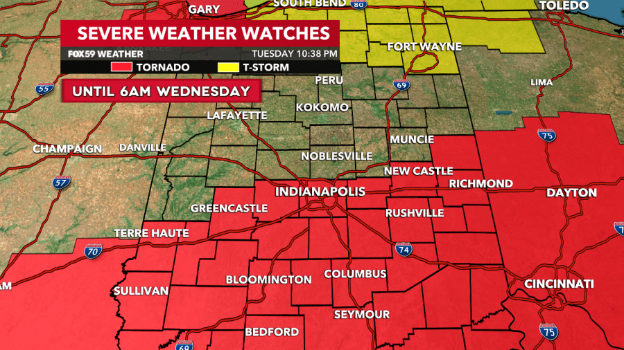
INDIANAPOLIS — A tornado watch has been issued until 6 a.m. for Marion County and the majority of central and all of southern Indiana as the threat of severe weather looms.
The National Weather Service announced that a tornado watch has been issued for Bartholomew, Brown, Decatur, Hancock, Hendricks, Henry, Johnson, Marion, Monroe, Morgan, Owen, Putnam, Rush and Shelby County until 6:00 a.m. Wednesday morning.
The watch said a few tornadoes are likely to form along with the possibility of scattered hail of up to two inches and wind gusts potentially reaching 70 mph. Parts of Illinois, Kentucky and Ohio were also listed in the watch.
There have been projections since 11:30 a.m. Tuesday southern Indiana in particular could be elevated to a level 3 risk for severe weather beginning Tuesday night and extending into early Wednesday.
There is a risk for tornadoes, winds and hail throughout central and southern Indiana. According to previous reports, a cold front is likely to pass through and this has a high potential to generate fire-up storms, with previous projections stating that the storms could last until around 4 a.m. Wednesday.
Comments are closed.